 It was the 13th Century Map of Britain, created by Matthew Paris, a Dominican Monk, that - in the time when she was in graduate school at the School of The Art Institute of Chicago -- inspired Caydance's interest in medieval maps.
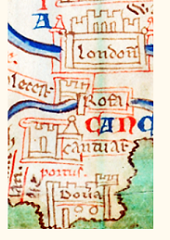
According to the British Library, where this map is housed, Matthew Paris was not known to have traveled very far from his home at the St Albans monastery. And yet, this map -- from Scotland (North of Hadrian's Wall; depicted accessed by a bridge); to Wales (labeled "the City of Merlin"); to a seemingly geographically misplaced Dover -- contains descriptions of 252 places. The whole is somewhat faded; the geographical placement is often questionable, but the sea that surrounds Britain is bluegreen; the rivers are bright blue; place names are blue or red; and the whole is enchanting.
 Caydance was photographing details to show her students. Creating clear details took longer than expected. Across San Francisco Bay, the sun was setting.